
Extension module – Documenting – Planning
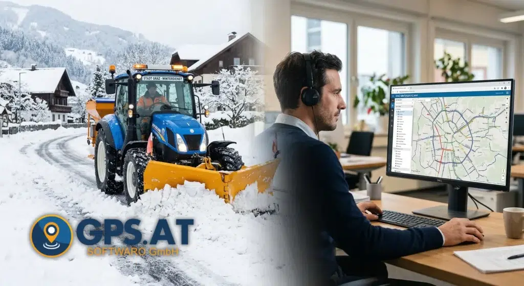
Construction yard manager software for winter services and telematics


 (2)")
GPS tracking in winter service
GPS tracking devices record the routes taken by the gritting vehicles. Site managers can display and document the lanes.

Spreading data application
The winter service spreader data (spreader ON/OFF, spread rates, brine/salt) is documented with the GPS lane.

Red-green comparison
Completed winter maintenance tours and work sections are GREEN displayed. Areas that have not yet been visited or gritted are RED.


Route planning for building yards
Feedback from experienced winter service managers was taken into account when planning the winter service routes.
Site managers can draw routes and important areas on the map and add images, work instructions, detailed photos and map sections. This creates a digital work preparation that describes your winter service tours (but also for summer service or manual waste collection tours). The tour preparation can be easily planned and modified online and then printed out or sent to the employee in paper form.
Operation report with spreading data
With modern winter service spreaders in particular, it is not easy to determine the routes that have actually been spread using sensors. This is why depot managers need the RS232 connection to the control panel of the spreader so that the spreading data can be transmitted.
- The parameters actually set, such as spreading width, spreading quantity and material spread (salt and brine), are transmitted online and documented in the operating times report.
- By linking the recorded spreading data with the GPS time, the spreading data is more accurate than when using the set system time of the spreaders.
- The spread rates recorded by GPS are automatically totaled in spread reports and can be sent by e-mail or commented on or printed out using the smartphone app.


Tour plan for the driver on the road
The winter service driver receives a clear route plan in the usual paper form so that he can take his time to look at the route and the areas to be cleared. We think that the drivers of a winter service vehicle are already sufficiently challenged when they are on the road and are highly concentrated on carrying out the winter service, sometimes with centimeter precision. Any additional distraction (navigation device, smartphone app, …) while driving is useless for most drivers on the road, because they know their route and should really concentrate on what is happening on the road. The conventional tour plan on paper is intended for breaks and preparation.
If you still need a GPS navigation system, you can also follow the lane with a GPS navigation app on your smartphone.
Additional module – digital practical route planning with images and road sections
Tour planning video
You are currently viewing a placeholder content from Vimeo. To access the actual content, click the button below. Please note that doing so will share data with third-party providers.
More InformationAdvantages of digital route planning in winter service
Especially when it comes to liability issues, we have to prove that we have carried out our work to the best of our knowledge and belief. Hospitals are obliged to report accidents to the authorities. This naturally raises the question of whether the winter road clearance at the scene of the accident was carried out properly beforehand. With the help of GPS data, we can precisely track the routes of every vehicle on any given day.
Battery-operated locating device for manual winter service
We also have the ideal recording option for manual winter road maintenance. The BatteryTracker is a small, handy GPS tracking device that can simply be plugged in or taken along in the car.
The BatteryTracker is recharged via a USB-C port, just like a cell phone. The mobile GPS tracking device sends a GPS position every 15-20 seconds when it detects movement.
While working, you can read the device status via the LED display. You can see whether the device currently has GPS reception and is actively transmitting data. An almost empty battery is indicated by a red LED light.
The BatteryTracker is suitable wherever it is not possible to permanently install a device in the vehicle, for example because different vehicles or tractors are used for winter service operations, which can often be the case with subcontractors or machinery rings.


Gritting data acquisition with RS232
The winter service gritting data of almost all known winter service gritting equipment manufacturers can be recorded and evaluated in the Bauhof-Manager.
Compatible spreader manufacturers
The GPS Fleet software can record and transfer spreading data documentation and spreading data logs from various spreader manufacturers. If you as a manufacturer are not yet on this list, please contact us and we will implement your spreaders in our GPS Fleet software. We would like to point out that in individual cases the spreading data connection may not be technically possible despite being listed.
Spreader types: Schmidt CL or ES control panel, Schmidt DP400K or NU400K
Spreader types: VPAD control panel, STA95

Spreader types: ELMR-152-06, ELMR-150-060
Spreader types: K-Tronic 2 (RL-Tronic 2), K-Tronic 1, Basic
Spreader types: ELBE196-10, ELMR152-11 Premium, Ecosat 10, ELMR150-11 Premium
Spreader types: AXEO with Quantron K software version 1.41.00, AXEO with Quantron K2 software version 1.11.00, UKS with Quantron A software version 2.00.00
Spreader types: TS-PRO for T-R, TN-R, TND-R, TNS-R
Spreader types: Ice Fighter
Spreader types: IceTiger
Additional module – Can be used for summer and winter service – Operation logs and monitoring
Building yard manager software module in live use
You are currently viewing a placeholder content from Vimeo. To access the actual content, click the button below. Please note that doing so will share data with third-party providers.
More Information